Photo by Kurt Refsnider
2019 Course Description
Important! Due to logging operations in Flagstaff, the originally proposed route has been modified. The final version of the route for 2019 is described below. The final GPX file has been emailed to registered participants.
The course is roughly 280 miles and consists of two distinct loops. The total elevation gain for the route is about 21,000 feet, split evenly between the two loops. The start and finish is at Flagstaff Bicycle Revolution, located at 3 South Mikes Pike, sandwiched between Pizzicletta and Mother Road Brewery.
The first loop (125 miles) begins with a neutral rollout as the route heads south and navigates through the campus of Northern Arizona University. After about 1.5 miles, the route hangs a right on a portion of the Flagstaff Urban Trail (FUTS). Folks can start riding at their own pace after the group crosses Mt. Dell Road, roughly mile 3.3. Riders will turn right at mile 4.5 and follow singletrack for roughly 8.5 miles before reaching Woody Mountain Road. The route then heads south following mostly dirt roads and eventually descends Casner Mountain Trail to the red rock of Sedona (4,350 feet). Riders get to sample some of Sedona’s sweet singletrack as they navigate towards the bottom of Schnebly Hill Road. Riders should be sure to refuel and stock up on food and water before ascending Schnebly Hill Road. After crossing under Interstate 17, the route weaves its way east via a network of Forest Service roads to meet up with the Arizona Trail near Mormon Lake, Arizona’s largest natural lake. The route then follows the AZT north via mostly singletrack for a few miles before turning onto dirt roads, which riders will follow until reaching Lake Mary Road. After a mile of pavement, the route turns back onto singletrack that leads to the AZT and then back to Flagstaff. While the first loop is shorter than the second, it will likely be more physically and emotionally tasking.
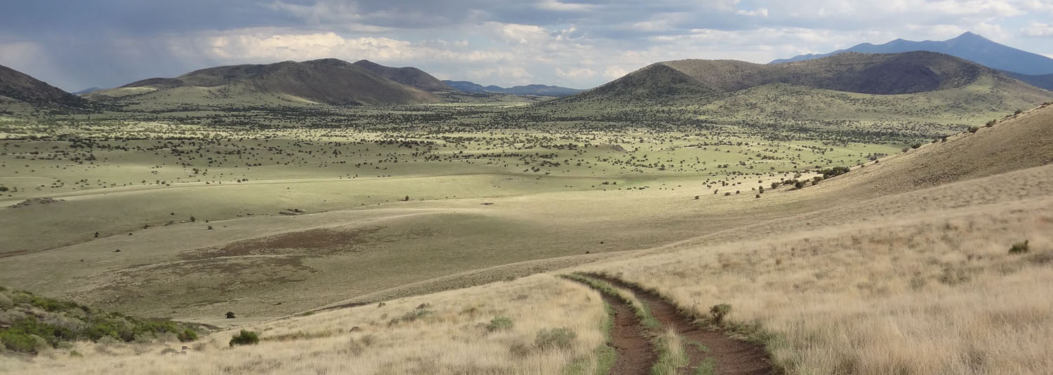
The second loop (155 miles) winds its way through Ponderosa pine forests and grasslands among hundreds of extinct volcanoes. The centerpiece of the second loop is the San Francisco Peaks, home to Humphreys Peak (12,633 feet), the highest point in Arizona. The Peaks have religious significance to several Native American tribes. In particular, the Peaks form the Diné (Navajo) sacred mountain of the west, called Dook’o’oosłííd, which means “the summit that never melts”. The Hopi name for the Peaks is Nuva’tukya’ovi, which translates to “place-of-snow-on-the-very-top”. After refueling in Flagstaff, the second loop begins by heading north on the FUTS towards Schultz Pass Road. Due to logging closures, the route will follow Chimney and then Lower Moto Trail before rejoining the AZT. While contouring the southern and western flanks of the Peaks, riders will be treated to roughly 20 miles of the best singletrack the AZT has to offer. After descending singletrack through an aspen grove, the course merges with the popular Craters and Cinder Cones Loop and follows spectacular dirt roads around the west side of Kendrick Peak (10,425 feet), passes by Slate Mountain (8,215 feet), and eventually descends on double track to Babbitt Ranch. As the route turns south, riders will cross over a lava flow and pedal by SP Crater, the first of several cinder cone volcanoes. The route then turns east around O’Leary Peak (8,919 feet) and onto loose cinder trails that link into the back entrance of Sunset Crater National Monument. Riders then follow pavement through the National Monument along recent lava flows before climbing a steep dirt road into Lockett Meadow and the “inner basin” of the San Francisco Peaks. From here, riders will climb to Waterline Road via beautiful but technical singletrack to the highest part of the route. While descending Waterline Road, riders will pass through remnants of the Schultz Fire while enjoying huge views along the west side of the Peaks. In order to bypass the logging closure, near the bottom of Waterline Road, the route turns left onto the pipeline and descends for a couple of miles to Deer Hill Trail. Riders will turn right on Deer Hill Trail, pass through Little Elden Springs Horse Camp, cross Elden Springs Road, and then turn south on the equestrian bypass of the AZT. There are often horses in this area and riders should follow appropriate trail etiquette. The route contours around the east side of Mount Elden (9,301 feet), and eventually passes along the rim of Walnut Canyon. The final few miles of the second loop are the same as the first loop. The route finishes at Flagstaff Bicycle Revolution.
Below are some important notes, including information concerning resupply options for food and water.
- Important: It’s a long way from the start to the first reliable water. Moreover, it’s likely to be hot after dropping down off the rim into Sedona. Be sure to start with enough water!
- Mile 37: Be careful descending Casner Mountain Trail! This is the most serious part of the route.
- Mile 61.2: You will turn left off of Dry Creek Road onto the Chimney Rock Connector Trail. You will need to hop a white fence to continue on the route. If you’d prefer not to lift your bike over the fence, you can continue south on Dry Creek Road and navigate your way through the neighborhood and eventually regain the route at the Thunder Mountain Trailhead.
- Mile 64.5: The final portion of Teacup Trail has been rerouted and disagrees with GPX track. Stay on obvious trail. GPX track needs to be updated.
- Mile 67.3: Shortly after merging onto Highway 89A, you’ll have a few options for stocking up on food and water before leaving Sedona. There is a 76 gas station on the right side of Highway 89A at the second round about that has a modest supply of snacks. After turning south on Route 179, Arroyo Roble Marketplace is on the right side of the road. There is a Circle K on Route 179 about a quarter of a mile past the turn onto Schnebly Hill Road. If you want to grab a meal, there is a Burger King on the right side of 89A just before the second round about and Oregano’s is a short distance south on Route 179. Both of these are on route. In addition, Starbucks, Chipotle, and Wildflower Bread Company are in a shopping plaza on a hill on 89A a bit north of the intersection with Route 179. There are also a few bike shops in Sedona. Over the Edge and the Fat Tire Bike Shop are the closest shops to the route.
- Mile 79.6: There is a water spigot at the ADOT yard just before crossing under Interstate 17. The spigot is located near a ramada in a grassy area by some houses. If for some reason this spigot is turned off, you might consider riding north on the interstate to the town of Munds Park, where you’ll have access to food and water.
- Mile 93: In the event of an emergency, you can detour a few miles off route to Mormon Lake Lodge.
- Mile 101.7: Weimer Spring is just south of the road. You’ll need to filter/treat the water.
- Mile 116.4: The Lake Mary Country Store is a short distance south on Lake Mary Road.
- Mile 125.1: Just north of the turn on E. Franklin Ave, there is a shopping plaza with REI, Wildflower Bread Company, and Whole Foods.
- Mile 125.5: As you pass through downtown Flagstaff, there are several restaurants. Depending on the time of day, consider stopping at Tourist Home Cafe (on route), Macy’s Coffee House (2 blocks off route), Diablo Burger (1 block off route).
- Mile 129.7: Just north of the turn on Schutlz Pass Road, there is a Shell gas station on the right side of Highway 180.
- Mile 141.2: Alfa Fia Tank is a short distance to the west. You’ll need to filter/treat the water.
- Mile 173.3: Tiptop Tank is a fairly consistent stock tank on the left side of the road. You’ll definitely need to filter/treat the water.
- Mile 190: Where the AZT merges in from the right, there is a public cache box hidden in the bushes. Do not take any water (or food) that is designated for an individual. The ride organizer (Dana Ernst) will stock this cache before and after the ride.
- Mile 230.6: There is a drinking fountain and a vending machine at the Sunset Crater National Monument Visitor’s Center, which is on the left side of the road.
- Mile 237.2: Just as you enter Lockett Meadow, there is a small pond on the right. You’ll need to filter/treat the water.
- Miles 238.5-247.5: There may be downed trees on Waterline Road. Most of them are easy to lift your bike over, but some of them are a bit annoying.
- Mile 250.5: The GPX track entering the horse camp after descending the pipeline after Waterline Road is stupid for about a quarter mile. Not It’s best to just stay on Deer Hill Trail into parking lot of horse camp. This needs to be fixed.
- Mile 251: About a mile of the AZT has been rerouted and disagrees withe GPX track. Moral of the story, just follow the trail. This needs to be fixed.
- Mile 255.1: Shortly after passing through a tunnel under Route 89, you can access the Conoco Travel Center (open 24 hours) by turning right on double track. This is a very short distance off route.